 Live Music Archive
 Librivox Free Audio
 Metropolitan Museum
 Cleveland Museum of Art
 Internet Arcade
 Console Living Room
 Books to Borrow
 Open Library
 TV News
 Understanding 9/11
tv News4 at 6 NBC October 29, 2012 6:00pm-7:00pm EDT
6:00 pm
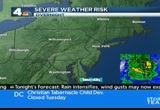
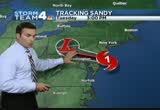
it started about 25 minutes ago. our hurricane sandy coverage begins with chief meteorologist doug kammerer, who has been tracking the storm throughout the day. doug? >> yeah, watching this storm out there right now, you can see where this is. right now, down through portions of cape may county, new jersey, that's where it's coming ashore right now. it was moving extremely fast, at 28 miles an hour. but looking at some of the latest imagery here, it looks like it's really starting to slow down. waiting to see what's going on. you can notice very dry air wrapping around the center. and the rain just cutting off. right now, right around the philadelphia area. they're no longer seeing the heavy rain. we, however, are continuing to see the heavy rain. the latest advisory as of 5:00, had winds of 90 miles an hour. a very strong category 1 storm. the pressure down to 940 millibars. this storm has now set all-time low pressure records for atlanticcity, for trenton, new jersey and for philadelphia. all-time lowest pressure ever
6:01 pm
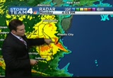
recorded. and that goes back to the super storm of '93. even beating the super storm of '93, that was the benchmark for many meteorologists. the one we all learn about in school. i guarantee you we'll all be learning about sandy. as we move through the next day or so, sandy just making its way north of new york. what will keep us in the wind. it will keep us in the rain, too the rain is slacking off around atlantic city, toward philadelphia, atlantic city coming in with winds of 70 to 75 miles per hour. this is the eye wall, right in through portions of cape may county, new jersey. this is cape may county. this is where wildwood is, rehoboth beach right here starting to see some of the outer bands making their way through, too. we'll start to see some of these bands, this one right in here, a strong band coming across the chesapeake bay. the winds are picking up very quickly. they will stay up all night long. we're seeing numerous trees down across the region. we're looking at a lot of power outages out there. you can just see the rain
6:02 pm
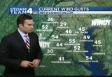
continuing from the east. so right now, along 270, rockville and gaithersburg and sterling, the heavier rain right now. fredericksburg, leonardtown, also seeing that heavy rain. everywhere along the chesapeake seeing that rain. to the west, it's not rain, winchester seeing the rain, but it is snow. back towards petersburg, west virginia, around luray, around the shenandoah valley, we are seeing snow, especially at elevation. there are blizzard warnings out there. but the rest of us are just seeing the winds. these are the strongest winds we've seen so far today. 55-mile-an-hour wind gusts in washington, 52 in martinsburg. as i mentioned, we're just getting started. >> thanks, doug. breaking news out of fairfax county. in the past few minutes officialsrdered o a mandatory evacuation of two streets in the huntington area. on fenwick drive and arlington terrace are being told to leave immediately. they say power's going to be
6:03 pm
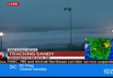
shut off as a matter of public safety there. if folks in that area need transportation, buses will be available at 2400 huntington avenue. the areas hardest hit so far have been rehoboth beach and dewey, delaware. the storm surge is creating huge waves down there. wendy rieger has been watching events unfold from rehoboth beach. wendy? >> reporter: wow, jim, we're sitting here, we're going to push out. look at these waves. they looked like they've gotten to be about 20 feet. look at that. it is amazing. we'll just be sitting here talking, and then we'll go, oh, my god, look at that! it is something to see this. and here's the other thing. i don't know if you guys were watching a couple of hours ago when i was down on the beach. the tide is coming in, and it is now coming up to that point. so we've got high tide coming up in a bit. we've got a full moon. and we have this storm pushing stuff in. it's going to be really ominous
6:04 pm
at this point. feeling kind of ominous, because it's starting to get dark. this day has been quite an interesting little day here on both sides of this beach. the winds, we're on the rooftop of the atlantic sands hotel. so it's unobstructed. some of the waves have come over, but they go back in. as you can see, the sea is still in its place. >> i figure it's best to wear less, hence that way the wet cold material doesn't stick. it's just wet and cold atmosphere. i'm playing scientist. poorly, but i'm doing it. >> here you go. >> the boots are waterproof and the coat is waterproof. >> oh, my goodness, your pants are see-through. we were talking about how calm it was on the ocean side. that's because all the wind had whipped back around and was really pushing this water in from the bay side. oh, i feel for some people down there.
6:05 pm

they have cars under water. it's looking like the ocean over here. this is an example of how strong this wind is. this is the bay. this is the bay. been a while since i covered a hurricane. and i am reminded, note to self, waterproof mascara. waterproof mascara. well, maybe i've had an interesting little day here. it hasn't been interesting, because the storm has had so many different personalities today. the bay side over here in rehoboth did flood, and flooded at dewey pretty significantly. no flooding here. but we are waiting to see what the night will bring, now that as doug just told us, this storm is ever so close. and will be going on top of us so to speak just to the north. we're going to see what happens with this high tide. it looks like we have another 20-footer coming in along here.
6:06 pm

you may not be able to see it because of the darkness. but oh, unbelievable what kind of surf this has kicked up. reporting live from rehoboth beach, i'm wendy rieger. back to you. >> hang in there, wendy. >> okay. >> every minute, another customer is losing power. we're already talking thousands of people in the dark. utility crews have brought in extra crews. but because of the high winds, they're going to have to wait a while. keith russell is tracking the number of outages from our newsroom. what's the latest, keith? >> hey, doreen, it started here, then it went here, and now it's approaching here. these numbers keep going up by the hour. as you said. let's start with pepco. at least 15,000 customers without power. up 2,000 in just a half an hour. dominion virginia, over 38,000 without power. up 20,000 in the last half hour.
6:07 pm
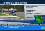
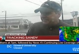
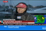
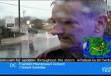
smeco, over 3s,300 customers without power. that's the one utility doing well so far. bge, almost 18,500 people in our area without power. that's since 5:30, up 5,000 since 5:30. of course, we'll continue to bring you the updated numbers all night long right here on news4. you can always catch the latest on nbc washington.com. back to you guys. >> thanks, keith. schools all around the area are announcing they will be closed again tomorrow. beginning in virginia, schools in anne arundel, calvert and charles county are closed tomorrow. that, of course is in maryland as well. public schools in culpepper, fauquier and fairfax and loudoun counties will be closed. in maryland, howard, montgomery, st. mary's and prince george's county schools also closed tomorrow. d.c. public schools also will be
6:08 pm

closed. president obama, local governors and other leaders are all asking all of us to stay home and stay safe through the rest of this storm. if you don't have what you need at home, chances are the stores don't have it either. >> pat collins has been out in montgomery county all day. he's up on i-270 in rockville. pat? >> reporter: jim, i've been to gas stations that don't have gas. i've been to radio shacks that don't have transistor radios. and flashlights, forget about flashlights. if you don't have it by now, this is no time to go out and get it. stay home. live without it. wait this storm out. now, we're on 270 near montrose road. the rain here is relentless. we get sudden gusts of win every now and again. the traffic is light. but getting through the roads, likely to become dangerous. let's hear now from some 270 road warriors.
6:09 pm

>> hard driving. win wind. >> reporter: hard to keep the control? >> yep. it's raining a lot. but it's not disrupting traffic at all. >> i can still see where i'm going at leas i'm glad i have traction control on my car. >> i just don't think it's that bad yet. i know it's going to get bad, what, about 8:00, just from what i hear on the news. >> reporter: you'll be home by then? >> i will. >> there was so few cars on the road it was actually easy maneuvering. >> reporter: good with the car, not so good with the umbrella. >> not so good with the umbrella. it doesn't look like it's going to make it. >> reporter: take a look at the rain on this pavement and how it's blowing around. this is what you have to look forward to if you get out and drive in this kind of stuff. it's only going to get worse. and again, i have to repeat it, if you don't have it, don't go out and get it. live without it.
6:10 pm
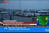
it's time to get serious, stay home, and wait this thing out. jim, back to you. >> sounds like good advice. thanks, pat. people inhe district are ying to make the best of this tough situation. tom sherwood has been all over town today. right now, he's at the southwest d.c. waterfront. tom? what's it like down there? >> reporter: well, the wind is really picking up. i wish i were inside one of those boats over there. the whole nation's capital is shutting down for sandy. there's no school tomorrow, no government office open, no early voting. but hey, think twice before you try to take a cab anywhere. some of the city's 6,000 taxis were among the few cars on the road. the taxi commission has surprised customers by announcing each cab can impose a $15 emergency fee on top of any other fare. even some cab drivers didn't like that. >> they said you can charge $15 plus the fare.
6:11 pm

well, i try to be a little more conscientious being that we're all living in hard times. >> reporter: elsewhere around the district, the city was setting up five shelters like this one at emory recreation center on upper georgia avenue northwest. >> we have five recreation centers open in case your power or your heat goes off. and you can come here for safe haven. we'll be here for the long haul. >> reporter: all around town, people were stocking up for tonight's version of the storm. is that beer? >> yes. >> reporter: that's a craft beer? >> yes, from vermont. one of our favorites. >> reporter: you can't have a storm without a choice of beer. >> exactly. we went with the dry champagne on a wet day as well. >> reporter: well, again, the whole city government is closed tomorrow. and right down the walkway here, there's a hurricane party at one of the boat owners.
6:12 pm
i might check on that in a few moments. tom sheer wood, news4. >> be careful out there, tom. is it legal for the d.c. taxy commission to just suddenl impose a $15 fee like that? >> reporter: yes, it is. the mayor was asked about this fee, and he said this sa good thing because it will, a, keep the cabs on the streets, and keep the people from routinely going out and getting a cab when they should be staying home. so the $15 fee should work to get a cab only when you want one. and keep some cabs out on the street if you need one. >> thanks, tom. while you're at it, why don't you drop by wherever the guys are with the -- >> the craft beer? >> and the champagne mermossas and all that. that's the news we want to hear tonight. >> reporter: well, i would have to be in the 11:00 story.
6:13 pm

>> we understand. you've got all night, tom. >> reporter: thank you. >> coverage of hurricane sandy continues. whiteout conditions to our west. the storm is dropping a bunch of snow in west virginia. do you want to catch a flight? sandy's not going to let that happen. i'm adam tuss at reagan national. tough call for drivers in falls church. we'll tell you what's going on out in northern virginia. photos of the trees coming down. keep the storm pictures coming. send them to ic@nbcwashington.com. >> keep track of hurricane sandy by downloading our free storm app, search nbc washington weather. [ minto ] you know, those ads saying mitt romney
6:14 pm

would ban all abortions and contraception seemed a bit extreme. so i looked into it. turns out, romney doesn't oppose contraception at all. in fact, he thinks abortion should be an option
6:15 pm

in cases of rape, incest, or to save a mother's life. this issue's important to me, but i'm more concerned about the debt our children will be left with. i voted for president obama last time, but we just can't afford four more years. [ romney ] i'm mitt romney and i approve this message.
6:16 pm

anyone trying to get out of town tonight is having bad luck. transportation reporter adam tuss is out at national airport now where every single flight has been canceled until further notice. adam? >> reporter: yeah, jim, as you
6:17 pm

can see behind me, the wind picking up here. certainly no flights getting out of dca right now, no flights out of dulles, not out of dwi marshal. you should expect more of the same tomorrow. obviously you can't fly in this kind of weather. and there are no planes here at reagan national. they're in other cities where they're stationed. they'll all have to be brought here later on at a different time. if you're here, you're going to have to ride it out at the airport. airport officials tell us you shouldn't expect things to get back here at the airport for a number of days. it's going to take a while to sort all this stuff out. reporting live at reagan national airport, adam tuss, news4. >> we're dealing with winds and rain to our west, the problem is snow and a lot of it, parts of west virginia are already seeing snowfall in the mountains. they're in a blizzard warning and could get as much as three feet of heavy snow in the next few days. the snow could be great news for ski resorts that can open for business early this season. wow. give us a sense, doug, we've
6:18 pm

been watching this since last night, and all throughout the day and all the doubters who thought, you know, this was over, overforecast, now are convinced. where are we? are we at the mid point of this thing? >> we are at the beginning of the worst of it. if that makes accepsense. >> yes, it does. >> we said yesterday it would be between 5:00 p.m. and 5:00 a.m. i think that's going to be on par of where we're going to be today and the rest of night tonight. we can expect to see winds like this and higher throughout the night. as we get heavier rains, too, what's going to happen is, the water is going to continue to get down to the roofs, and the soil, and the rain, and the trees, rather, the trees are going to start coming down across the region. we've already seen that around parts of the region. it's hard for the trees to stay rooted once the ground is saturated. sandy is making its way onshore right now. i still have not heard the confirmation from the national
6:19 pm
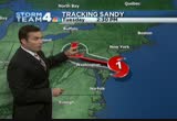
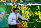
hurricane center, but it does look like the eye wall is right onshore in cape may county. one thing of note, though, look at the very dry air on the back side of this of the i don't think that will affect us. but it is affecting philadelphia. philadelphia, dry as a bone right now. they're just seeing the wind. for us, we're seeing the rain and wind. the storm just off the coast, the latest from the hurricane center. winds out of the west-northwest at 28 miles an hour, wind gusts at 90 miles an hour. it is going to slow down. by tomorrow around 2:30, it will only be in central portions of pennsylvania. we're still going to be dealing with this. our winds will continue to sht. this is the brand-new bridge, brand spanking new. remember the old bridge right here on the side road? all underwater. a friend of mine just asked for pictures of ocean city, said, do you have any pictures of ocean city? yeah, the pier on fagers island, my cousin jim asking about that.
6:20 pm
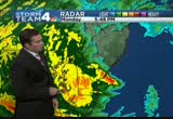
this is mackey's on the bay. notice the water has come in from the bay, and this is the way the winds are blowing, northwest. this will be the case again tonight with high tide coming around 8:00 on the beaches. and a little bit after back toward the bay. they will see flooding again tonight in portions of the beach. here's the dry air i was talking about. you can see the outer bands coming in through new york city. they have reported wind gusts upwards of 80 to 90 miles an hour along long island. for us, we're just going to continue to see these bands make their way in. here's the eye wall right here. the center right around here. maybe not quite onshore just yet. just waiting to see as we move inland. the waves continue to come in. once again, you'll see 30, 40, 50-mile-an-hour wind gusts and then it will go still, and then you'll see another band come through with heavy wind and rain. this is the heaviest bands right here. it will continue to make its way across our region.
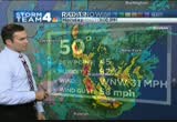
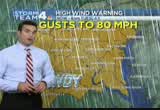
6:21 pm
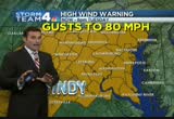
heavy rain and wind in anne arundel county, and leesburg, and winchester. let's take a look at those winds for you. gusting to 48 miles an hour in washington. we did have a 55-mile-an-hour wind gust last hour. 52 in martinsburg, 52 in winchester, right now 45 in annapolis. everybody here with the exception of frederick and culpepper, at or above tropical storm force. that's why we have the high wind warning in effect. gusts potentially 60, 70, maybe 80 miles an hour. that might be a little high. but that's coming from the national weather service. i think more like 60, maybe 70, if that. we're going to continue to see very strong winds. the rainfall, almost three inches in washington, four inches in annapolis, and about four and a half down towards pax river. still seeing the rain coming down. we'll continue to see more rain. that's why every county in our viewing area is now under a flood warning. a flood warning as we are going to see the creeks and rivers continue to flood. the next couple of days will get better. tomorrow we'll get a little bit better with a high of only 47.
6:22 pm

tomorrow will be rather cold with rain likely. 54 on your wednesday. that, of course, is halloween. right now, thursday, friday, saturday, sunday and monday, all look dry. cool, but dry. so we're going to be able to clean up after this storm finally moves on. >> we are going to need it. more to come. thank you, doug. with more wind and rain from sandy coming our way, flooding is already becoming a serious problem in the huntington part of fairfax county. officials have now ordered mandatory evacuation on two streets. julie carey is live there with more details. >> reporter: fairfax county ems workers just started to pour into this area a short while ago. a squad car down there down the street. a lot of fire crews. they are just getting ready to go door to door on two streets, fenwick street and arlington terrace. they are going to have to evacuate. now, a lot of the residents heard online earlier, and what
6:23 pm
fairfax county told them once they made this decision, the power is going to be cut off to these homes. so that's a pretty powerful incentive to cooperate and to head out. so again, some folks packed up their bags. headed out on their own. in fact, we talked to one man a little while ago, as he headed out of the neighborhood. . >> we got a little advance of this on the west. so, yeah, power is going to be shut off. >> what do you think of that? you haven't seen the water come up yet. >> i m my reservations about it, but twice i've been rescued from my house in a boat or something like that. so this time i'm taking the initiative and not waiting. >> reporter: residents can stay with friends or family in the area. fairfax county has opened an emergency shelter just down the road on telegraph road.
6:24 pm

they'll transport people from here to there. the flooding has not started yet. cameron run is still within its bay. they expect as the high tide comes in tonight and as the storm kicks up around 8:00, between 8:00 and 10:00, that the waters could come out in this area, could get flooded yet again. it has been flooded three times in the last ten years. we'll be standing by tonight to see if this becomes time number four. reporting live in fairfax county, julie carey. >> our coverage continues. next up we'll take a look at all the damage in montgomery county. >> it's going to be a long time tracking this storm. you can get updates 24/7 on nbcwashington.com, search sandy. and follow @nbc washington on twitter. or like nbc washington on facebook. we'll be right back.
6:25 pm

teacher: this is west virginia, pennsylvania, delaware. and. every year marylanders spend five hundred and fifty million gaming at casinos in these other states. question seven will build a new casino and bring table games to baltimore... generating hundreds of millions for schools. and that money has to go to education. it's the law. so vote for question seven. so we can stop spending all that money here, and keep maryland money in classrooms like mine. when we think no one is looking. is what we do... mitt romney: believe that they are victims. anncr: mitt romney thought no one was looking when...
6:26 pm

he attacked forty-seven percent of americans. his companies shipped jobs overseas. his plan cuts millionaires' taxes, but raises yours. he'll voucherize medicare... and make catastrophic cuts to education. so remember what romney said... and what his plan would do. president obama: i'm barack obama and... i approve this message.
6:27 pm

♪ ♪ [ male announcer ] combine the pnc cashbuilder visa credit card with a qualifying pnc performance select checking account and earn 75% more than cards earning 1% cash back on almost everything.
6:28 pm

biggest concern for a whole lot of us in the storm, the power going out. tens of thousands of us are already in the dark because of hurricane sandy. news4's jackie bensen is along georgetown pike in mclean, virginia, where crews were out working on the lines. hi, jackie. >> reporter: hello, doreen. you know, the folks in this neighborhood, take a look at this sign over to my left, they have power. the reason they have power is the hard work that we witnessed a short time earlier. i think we have pictures to show you of the dominion power crews out here just as it was getting dark, after a tree was removed that had fallen down in georgetown court this afternoon when the wind picked up, brought down power lines. those crews got in there, up on the buckets in these high winds in the torrential rain, in a very dangerous job. and worked so they could get the lights back on to the people in this neighborhood. and then they packed up and took off and west to another one. even while this storm is going on, they're working to get the
6:29 pm
power back on. but the local utilities do tell us that once we get to the very serious part of the wind, it makes that job of going up in the bucket trucks too dangerous and they're not able to do that. again, we're starting to hear reports of more and more trees down in this area. and as it gets darker, we're also starting to see some of the roads, the typical roads in this northern virginia area starting to flood. you want to be careful when you head out tonight. reporting live, jackie bensen, news4. >> jackie, thank you. >> doug made a good point, i guess really beginning last night, if not a couple of days ago, that the worst of this would not be begin until about this time. and doug, it seems to be it's right on schedule, huh? >> yeah, right on schedule. the model, the forecasting for this storm has been tremendous. it really shows you just how good we have -- or how far we've come as forecasters to be able to forecast this so far in advance. we've been talking about this, chuck bell mentioned it last sunday, so for more than a week
6:30 pm
we've been talking about a major storm making its way along the east coast. that goes for all the meteorologists, including the national hurricane center. winds gusting upwards of 50 to 55 miles an hour. now we have a peak gust, we are seeing the worst of it now. it just starting. now gusting to 58 miles per hour out at the airport. and we're starting to see the higher gusts. current temperature is right now at 50 degrees. it's on the cold side. here's the storm making its way onshore. if it's not onshore right now, it is very, very close. you can see the banding continuing to come through. i want to show you this band right here. watch the last frame. right here. look at all this heavy rain. that's also where we're going to see some of the strongest winds. it's coming in through annapolis, prince george's county, dunkirk, waldorf, cam spring. get ready. this is where you'll see the
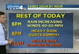
6:31 pm
winds increase by another 10 to 15 miles per hour. you'll see the rain come down very, very heavily. some of these areas along 95, you see this area of orange, those are the even stronger winds that the punch through that very heavy rain. current wind gusts, there's the 58-mile-an-hour wind gust right now around washington. 44 in manassas. 50 miles an hour down at pax river. hour by hour, here we are at 6:00, winds 40 to 50, gusts to 60. by 8:00, gusts to 60 miles an hour or more. and then overnight tonight, around midnight, heavy rain with the potential for damaging winds. so once again, we're going to see numerous trees down during this period. as we wake up tomorrow morning, hour by hour, about 8:00, rain likely. but notice the winds. back down to 20 to 30 miles an hour. so we've got about another 12-hour period of these strong, strong winds. tomorrow, we'll start to ease out of this storm, as the storm begins to ease away. we'll continue to keep you posted right here. >> thank you, doug.
6:32 pm

high winds, waterlogged ground, we're getting reports of trees coming down across the area. including a very close call in bethesda this afternoon. let's go it tisha thompson with the latest from montgomery county. tisha? >> reporter: doreen, i have to tell you, in just the last hour the wind has really picked up. we have been in and out of montgomery county all day. and the water is starting to rise in the creeks. it hasn't quite flooded out of the banks yet. but the ground is now wet enough, it's now saturated enough where trees are beginning to fall. >> one of the scary things in my life. >> reporter: she was standing next to her window when she saw a tree start to fall. >> all of a sudden i just saw the ground start to come up. all the roots coming up. and boom, tree went down right there on our neighbor's house. >> reporter: inside the bedroom, this mother who says when she heard the boom, she went running to find her son.
6:33 pm
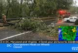
he was safely downstairs. it was only after firefighters arrived did she realize the tree had come crashing through the roof and barely missed her. it was a different story in germantown at the intersection of frederick road and brink road where the 19-year-old driver of this pathfinder crossed the double yellow line, killing the 66-year-old man driving the oncoming jaguar. roads are starting to shut down in montgomery county as trees are starting to fall, like this one on old baltimore and barnsville and macarthur boulevard. just a few blocks from jamie lee's house. >> i'm very nervous. we have huge trees in this neighborhood. a lot in the backyard. so i think we're going to be staying in the basement tonight. >> reporter: i asked jamie lee what it sounded like when that tree came crashing down. she said that was the scariest thing of all. she said it was silent. she said the ground was so saturated, it looked like the tree was falling out of butter. it was only until it hit the
6:34 pm

actual building that you heard anything. doreen, jim, back to you. >> that is spooky. tisha thompson in bethesda. >> getting nasty all over the place out there. not only northern virginia, montgomery county, but prince george's county as well. where it's already flooding and trees down as well. tracee? >> reporter: well, i'm standing in the midst of a tree that is lying on top of a car. if you look over here, you can see the tree crushed this vehicle. we talked to the owner of the tree earlier. let me show you what it looked like on 23rd parkway in temple hill when this tree went home a little while ago. these folks are all in the dark. not because of this tree. they said they lost their power about an hour ago. but this was a huge mess. especially for the homeowner. they haven't been able to get the tree off of his car yet. what was most important is that they opened up 23rd parkway which they were able to do here, so traffic can come through this way. but it's been a mess everywhere.
6:35 pm

and the wind is picking up. and so is the rain. and it's getting colder and colder out here. we talked to the homeowner about this tree coming down. here's what he had to say. >> all of a sudden we heard a bang, and then the tree fell down. my wife said, it hit the car. glad to see somebody out here now. plus we don't got no lights either. so pepco is here, the tree people are here, so i'm happy for right now. >> reporter: pepco was here. but they were not able to get the power up in this neighborhood. they're still in the dark. but it is great to see that they actually have the crews out here, paying attention to these areas losing power. i remember in storms past we would be in dark neighborhoods and not see a truck at all. we've seen at least two. so they are trying to do -- in fact, that truck making its way back down the street right now. so they are trying to take care of the power outages before it gets really bad. so we have seen wind gusts, and
6:36 pm

then the wind kind of die down a bit, and then gusts again. there goes that pepco truck making its way past me right now. again, this neighborhood in temple hills, they are in the dark. we've seen dark intersections as well. remember, when you come to the dark intersections, you have a four-way stop you have to deal with. we saw a few of those on branch avenue. jim, the good news is, as we drive through prince george's county, there's just a few cars on the road. lots of folks are staying in the house and not coming out into this mess. and i mean, it is messy out here. reporting live in temple hills, tracee wilkins, news4. >> two trucks. >> the power company's had a lot of advance warning about this storm and it seems like, at least we hope they're better prepared this time. coming up next, if you have a generator, a warning before you use it. liz crenshaw with potentially life saving tips. we've been following this hurricane since the beginning. and we'll have more, including
6:37 pm

the rest of the eastern seaboard. >> live conk of hurricane sandy continues all night long. stay tuned for "nightly news" at 7:00 with brian williams. and we'll be back at 7:30 with our live continuing coverage of sandy's effects around our region. anncr: seven-hundred-thousand jobs. that's what the plan george allen supports... would cost our economy. newspapers called it "economically destructive." like allen's votes to give tax breaks to companies... that ship jobs overseas, his economic plan would... help big corporations, devastating the middle class. allen even voted against tax breaks for small businesses. virginia can't afford to go back to george allen. the democratic senatorial campaign committee... is responsible for the content of this advertising.
6:38 pm

imillion dollars for maryland one hundred schools.ty... question seven will double it. rushern baker: question seven will add table games and... a new casino, generating millions of dollars... every year, without raising taxes. leggett: and audits will ensure the money goes... where it's supposed to. more jobs, and millions for schools. baker: question seven will be good for our kids... our teachers, and our schools. leggett: keep maryland money in maryland. baker: please vote for question seven. leggett: vote for question seven.

6:40 pm

a lot of people have learned their lesson. they know that when a storm comes, it could be days before they get power back on. so they went out and bought themselves a generator. >> seems like a really good idea, but liz crenshaw joins us with a reminder about how dangerous generators can be if you don't use them properly. plus what you need to understand about insurance and hurricanes. too late now to understand that, isn't it? >> with all the severe weather we've seen in recent years, a lot of people have invested in portable generators. but in every storm, homeowners do become seriously ill and some even die because of carbon monoxide poisoning from those generators. remember, generators do produce carbon monoxide. it's an odorless and colorless gas and it can kill.
6:41 pm

never use your generators indoors, or outside near a window or vent or air intake. it's important to keep generators dry, but you don't want to use one in a garage under any kind of porch. always use a heavy-duty outdoor extension cord from the generator to the appliances you want to run. overloading that extension cord will start a fire. now, a reminder about homeowners insurance. flood damage will not be covered if you don't have a flood insurance policy. is it too late to get one? yep, it is too late to buy flood insurance for hurricane sandy. fema said there's a 30-day waiting period after you even apply, and pay for the premium, before the policy is actually in effect. the policy will not cover a loss in progress. so too late to buy flood insurance. but your homeowner's insurance will cover damage to your house from rain or trees from your storm but not actual flooding. but there's something new called the deductible, the hurricane deductible. just for hurricane damage.
6:42 pm

unlike a standard homeowner's insurance policy, which maybe would have a deductible of $500 or $1,000, the hurricane deductible would be 1% to 5% of the insured value of your house. you could be paying thousands of dollars before that hurricane coverage will kick in. so just realize that you're sort of covered, but you might be paying a whole lot more when you take a look at the new thing called the hurricane deductible. >> and you're only covered if it comes from the sky, not from the ground. >> without flood insurance, you're doomed. hurricane conk, yeah, it's rain and oops, we've got this hurricane deductible. i've got my eyes on this one. we'll try to keep an eye on the coverage over the next couple of days. >> you're darned if you do and darned if you don't. >> yeah. >> thank you, liz. >> okay. all right. we're going to take a quick look at the scene at the beach on the waterfront on rehoboth beach. doug said high tide is coming at
6:43 pm

about 8:00 there. wendy's been telling us about the growing surf at rehoboth. doug's got the full forecast coming up next. stay with us. teacher: this is west virginia, pennsylvania, delaware. and. every year marylanders spend five hundred and fifty million gaming at casinos in these other states. question seven will build a new casino and bring table games to baltimore... generating hundreds of millions for schools. and that money has to go to education. it's the law. so vote for question seven. so we can stop spending all that money here, and keep maryland money in classrooms like mine.

6:45 pm

mitt romney: believe that they are victims. anncr: mitt romney thought no one was looking when... he attacked forty-seven percent of americans. his companies shipped jobs overseas. his plan cuts millionaires' taxes, but raises yours. he'll voucherize medicare... and make catastrophic cuts to education. so remember what romney said... and what his plan would do. president obama: i'm barack obama and... i approve this message.
6:46 pm

the situation is really getting funky up in new york and new jersey. michelle franzen reports from battery park now. michelle? >> reporter: at this hour we're starting to feel the wind gusts coming in with a vengeance here, and we're waiting for the high tide in the next hour and a half or so. that water is already lapping at the es pla naud here. we're keeping an eye on it all day. one of the areas evacuated as well as other areas of new york city, as a precaution. actually more than 300,000 people asked to evacuate and seek safer areas. coming up in the next few
6:47 pm

minutes, the george washington bridge will be shutting down, the last links. we'll be isolated in manhattan. the subway system, of course, shut down yesterday. mass transit, all the harbor traffic now closed, everyone, officials hoping in their safe place, hunkering down as sandy, of course, starts to lash this area for hours and well into tomorrow. >> thank you, michelle. >> michelle reporting from battery park in new york. and new york and the new jersey beaches are getting hammered. >> yeah, they have really getting hammered out there right now. also, you mentioned, michelle franzen up towards new york, long island really getting pummeled right now. we just had a wind gust of 82 miles an hour at islip, one of the airports out by long island. this is really a signature hurricane. but not signature in the way it's making landfall in new jersey. i don't think there's ever been
6:48 pm
a landfalling hurricane in new jersey. i've got to look that up. that's for sure. but it's coming to shore right now in portions of southern new jersey with winds of 90 miles per hour. the pressure down to 940 millibars. the movement was west-northwest at 28 miles an hour, but not sure where that is. i'm waiting for a new update from the national hurricane center because this is trying to make its way onshore right now. as it does, it will make its way just to our north here, very close to baltimore and just to our north. and what that's going to mean for us, it's going to literally stop and stall during the day tomorrow. that means this is a long duration event. we're going to have winds right on through the day on thursday. again, the strongest winds will be for about the next 12 hours or so. you can see the winds and rain, you can see the rain coming in here, the rain very, very heavy down towards the south where we have a little bit of a boundary setting up. this area right here, down to the south of fredericksburg, could easily pick up between five and ten inches of rain. you also notice this snow. blizzard warnings, even for our
6:49 pm
area. folks down around harrisonburg, shenandoah valley, you folks are under a blizzard warning with wind gusts up to 60 miles per hour, and some areas up to three feet of snow. one thing i want to show you is this band right here. notice the heavy rain associated with this. this is coming on through here. this is probably one of the worst periods of the storm that we're about to get right now. you're getting it in baltimore, annapolis. look down towards leonardtown. you're going to get strong winds around calvert county, chesapeake beach, and mechanicsville. heads up for you folks as this red area here, these reds making their way across the bay right in to you. here comes the yellow. tisha thompson was outside a few minutes ago saying it's really picked up here. you walk outside and that's exactly what you notice, things are really starting to pick up. let's take you through the overnight hours. 7:00 tonight, this is where we're getting into it. heavy rains gusting to 60 miles
6:50 pm
per hour plus. by midnight, heavy rain and damaging rains, trees down across the region, heavy rains by 5:00 a.m. winds 20 to 30 miles per hour, i think we'll start to see things calm down. winds upward to 40, 50 around that time. but we'll start to see things calm down around 5:00 tomorrow morning. the national weather center forecast for high winds goes through 8:00 tomorrow night. but i think that will be trimmed back tomorrow morning. but still, high winds around our area. nearly 4 1/2 winds around pax river. a lot of rain, and of course, we have flooding that is going on right now. we'll continue to see that across our region. this is our national harbor camera. the wind out toward the airport as we look across the potomac toward the airport, winds gusting near 60 miles an hour right now. we'll continue to watch that. i want to show you pictures near
6:51 pm

rehoboth beach. sandy making its way inland, the water back up toward the dunes, it's expected to go back over the dunes as it makes its way in. the wind has shifted to offshore. that could help them around rehoboth, could help them in areas around ocean city. it looks like it's almost fairly calm there. i wonder if this is actually the eye, as it's making its way over. we'll continue to watch as we move on through. this shot is right outside our parking lot. you can see the wind, you can see the rain coming on through. and as i mentioned, this is just getting started. we've got another probably 10 to 12 hours of this continuing through the night. >> all right. thanks, doug. we've got more news coming up in just a moment. we hope you'll stay tuned. and "nbc nightly news" is coming up at 7:00, right after this broadcast. brian williams will have a look at conditions up and down the east coast. and we'll be back at 7:30 with our live continuing coverage of how sandy is affecting our

6:53 pm

president obama: there's just no quit in america... and you're seeing that right now. over five million new jobs. exports up forty one percent. home values... rising. our auto industry... back. and our heroes are coming home. we're not there yet, but we've made real progress and the... last thing we should do is turn back now. here's my plan for the next four years: making education and training a national priority; building on our manufacturing boom;
6:54 pm

boosting american-made energy; reducing the deficits responsibly by cutting where... we can, and asking the wealthy to pay a little more. and ending the war in afghanistan, so we can... do some nation-building here at home. that's the right path. so read my plan, compare it to governor romney's... and decide which is better for you. it's an honor to be your president... and i'm asking for your vote... so together, we can keep moving america forward. i'm barack obama and i approve this message.
6:55 pm

wendy rieger, our storm girl, she's been covering storms around here for the last 20, 30 years or so. i don't think i've ever seen her so excited about big breaking waves as she was tonight. what's going on now, wendy? >> reporter: hi. well, i've got to tell you, jim, i'm starting to develop a love/hate relationship with this little ole storm, because when it starts getting me all excited and thinking it's a wonder to behold, it just does this, it goes all flat. and it starts looking like nothing much. kind of like my dating life. and so then i think, whoa, that's getting exciting again. then it goes all flat. right now we're in a lull. i don't know what this means meteorologically. we do have a high tide coming
6:56 pm

in, as you can see. the foam is starting to edge up closer once again to the fences, that protect the dunes. not that we want it to do anything overly dramatic. but we just want it to keep us awed. live from rehoboth beach. >> thank you, wendy. we know why, don't we, doug. >> i think you're in the eye, wendy. i think the eye is right over you right now. that's what happens, you get that lull, once the eye moves over, the winds completely shift out of of the other direction, in your case they'll be coming out of the south-to-southeast very quickly. you're going to see that change. you're going to be excited again. >> stand by. >> i don't know about her dating life, but she's going to get excited again. >> all right. >> 56 in ocean city, 51 in washington. we'll continue to watch these winds kicking up throughout the rest of the night. >> all right. that's our broadcast for now. we're going to go up there for
6:57 pm

just a second. >> nbc nicely news is coming up next with a look at what's happening nationally with this storm. and we will all be back for our live storm team 4 coverage beginning at we are all be back beginni will be on the air throughout the night, all night long, 7:30 tonight and on the air throughout the night. keep you up to date on what's happening with hurricane sandy. >> we're covering everything in our area, doug's area, my area, might even cover a little bit of doreen's as well.


241 Views
IN COLLECTIONS
WRC (NBC) Television Archive
  Television Archive News Search Service
Uploaded by TV Archive on
